We use our extensive experience and broad technical knowledge to assist our clients during all phases of the seismic data acquisition project. Kingfisher senior personnel have a combined 70 years experience, being involved in more than 300 seismic projects in some 60 countries worldwide.
 |
In the planning stages, a cost effective design is produced that takes into account available contractor resources, current technology, environmental and permit restrictions without compromising the project objectives.
We assist our clients with bid writing, bid analysis, budget forecast, contractor liaison, contract negotiation, contract writing and quality control specifications.
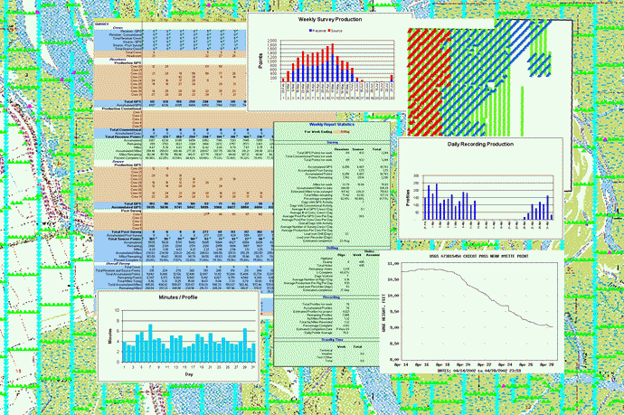
At the crew level detailed records are kept of the crews performance and production. Statistical analysis of this data makes it is possible to forecast completion dates, evaluate actual cost versus budget and to quickly identify areas of both strength and weakness in the overall operation.
Daily and Weekly reports are generated in the field providing management with details of the crews activity. These reports cover, permitting, surveying, drilling, crew layout and pickup, recording activity, budget analysis, cost analysis and HSE. All summary reports are submitted to management and client via email. A final report is produced containing all crew reports, digital photographs, maps, GIS database, etc. This final report is provided on CD-ROM or DVD.
GIS is used extensively to provide our clients with a variety of
displays showing crew progress from permitting through the final
recording phase of the seismic survey. This includes an interactive GIS
database including all surface and mineral permits with available
topographic maps, water depths, hazards, and aerial photography where
available.